From a biodiversity management perspective, the first step towards implementing integrated landscape management should be to use landscape ecology science and practice to understand how objects placed in the landscape, such as transport infrastructure, interact with biodiversity. Methods and techniques from this field of ecological research must be implemented as much as possible at all stages of the transport infrastructure life cycle, effectively forming it’s backbone (see Chapter 2 – Policy, strategy and planning).
Landscape ecology aims to understand and anticipate the effect of landscape elements such as transport infrastructure on biodiversity, ranging from gene spreading to ecosystem functioning. An appropriate spatial planning process should first define the scale that needs consideration for a given infrastructure and define biodiversity conservation targets, such as protecting specific habitat, species, ecosystem services or ensuring gene flow within the landscape. It should take a cross-sectoral approach and incorporate participatory processes involving all the relevant stakeholders within the infrastructure’s area of influence. Spatial planning based on landscape ecology approaches can be undertaken regardless of the transport infrastructure type and spatial scales.
The strategic planning and design phases of the transport infrastructure life cycle (see Chapter 2 – Policy, strategy and planning) are the first opportunities to avoid or reduce impacts on biodiversity (see Chapter 3 – The mitigation hierarchy). Spatial planning can contribute to maximising the biodiversity gains expected before and after the construction and upgrading phases through the implementation of mitigation measures. Identifying and prioritising the best places for implementing mitigation measures in the local spatial context will be fundamental to identifying the location of those measures. Finally, spatial planning is also useful to maximise biodiversity gains during the decommissioning phase by identifying the best restoration targets in the general spatial context of the transport infrastructure.
The following sections introduce two progressive approaches addressing the mainstreaming of biodiversity in infrastructure planning and management at the landscape scale, namely the consideration of Green Infrastructure and ecological networks as a first step and then the implementation of the mitigation hierarchy at the landscape scale as a complement. A following section then provides some participatory techniques aiming to increase stakeholder involvement to implement an integrated landscape management perspective.
Ecological networks as Green Infrastructure
Ecological networks are a key part of the Green Infrastructure in a region or country and are defined using a holistic interpretation of ecological functioning. An ecological network is composed of core habitats and ecological corridors, enabling species to move among core habitats or to colonise new areas. It must be used as a baseline to integrate transport infrastructure into the landscape through spatial planning which avoids impacts on ecological connectivity. Ecological networks should be assessed at a relevant scale and provide all information about ecological dynamics of a given territory.
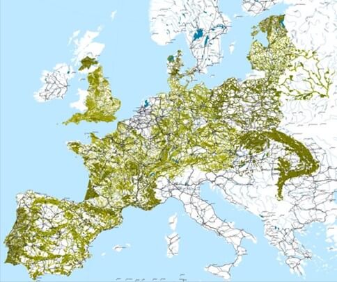
At European scale, the development of the Trans-European Transport Network (TEN-T) should take into consideration the ecological networks at the same scale (Trans-European Nature Network; TEN-N), defined by protected areas and large scale corridors, to enable an evaluation of the impacts on ecological connectivity (Figure 4.2.1). The same approach should be applied at smaller scales, although providing more tailored information specific to the landscape context. This information is valuable in the assessment of integration of a transport infrastructure with biodiversity dynamics at a multiscale perspective.
Ecological network identification must be undertaken during the planning and design phases of transport infrastructure development and upgrading with the aim of avoiding or reducing the impact on biodiversity (see Chapter 2 – Policy, strategy and planning; Chapter 3 – The mitigation hierarchy).
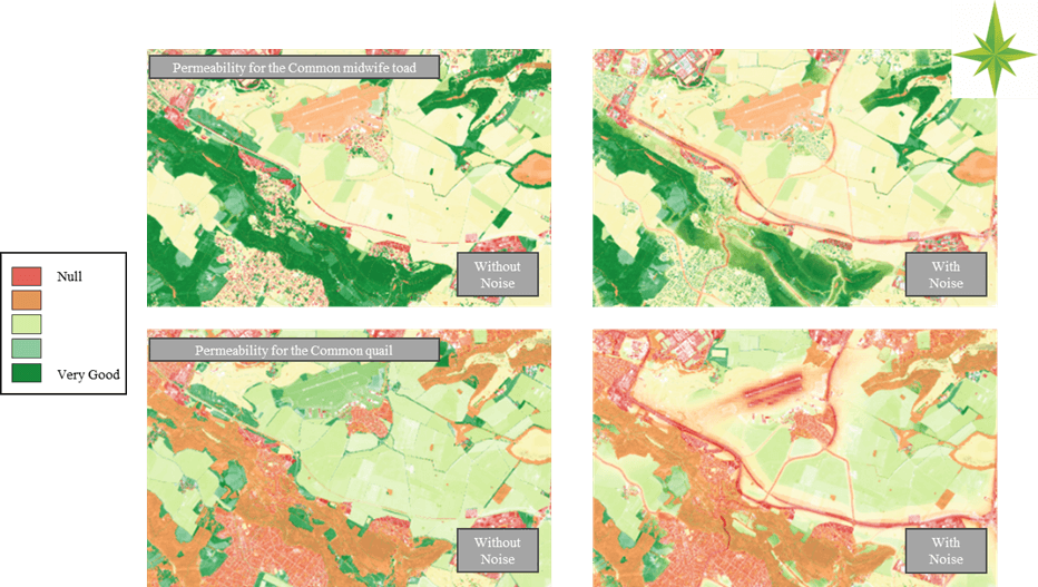
Other anthropogenic pressures within the landscape should also be considered, e.g., different land uses, soil erosion, water balance, air quality, light or noise pollution. In the case of urbanisation being the main constraint on ecological networks, urban related impacts and pressures should be considered in the ecological assessment. Noise, light and other pollutants must also be considered as they have strong impacts on species dispersal but also on their abilities to remain within a specific area and therefore on their local extinction rate (see Chapter 5 – Solutions to mitigate impacts and benefit nature. Measures to reduce disturbances). Thus, ecological network assessment must integrate at minimum a cross spatial analysis of anthropogenic pressures on the ecological network, including a comprehensive analysis of where and how the pressures affect the network’s functioning (Figure 4.2.2). Such pressures can reduce the quality of the habitat and impact functioning without changing the network structure.
In general, assessment of ecological networks should consider all pressures that could affect their effective functioning. If shortcomings in considering such impacts occur, then habitat quality and the functionality of an ecological network can be overestimated. This comprehensive approach allows the identification of areas where mitigation measures are needed.
Integration of landscape ecology in the application of the mitigation hierarchy
A further step in the integration of biodiversity within the design of infrastructure is the integration of landscape ecology in the application of the mitigation hierarchy (see Chapter 3 – The mitigation hierarchy). The best mitigation occurs on the early phases of transport infrastructure development and it involves the selection of the least damaging route alignment combined with sensitive design.
Planning for a mitigation hierarchy application which incorporates landscape ecology principles requires spatial and temporal identification of areas of high ecological value at the landscape scale which will likely become part of the Green Infrastructure. This first step includes the identification of the ecological network and its functioning as a part of an avoidance strategy. An avoidance strategy can hugely simplify infrastructure design and significantly reduce ecological impacts. Measures to reduce impacts implemented locally, can also minimise impacts at a landscape scale through, for example, wildlife passages. The design of reduction measures should take place in an iterative way together with avoidance (see Chapter 2 – Policy, strategy and planning).
Once the avoidance and reduction measures are set and the project’s residual impacts on the territory have been evaluated not only regarding the transport infrastructure but also other human activities, a compensation strategy can be developed. This approach can simplify the management of such a strategy and maximise ecological gains. Infrastructure designers, like any other project developer, should be involved in the planning process, including the assessment of impacts linked to their infrastructures and the programming of avoidance, reduction and compensation measures (see Chapter 3 – The mitigation hierarchy).
The results of this strategic planning must lead to a classification of mitigation measures, defined at different scales and enforced by different stakeholders. Measures associated with avoidance, reduction or compensation planned at the landscape scale are similar to measures designed at any other scale and should be designed to maximise biodiversity gains.
Strategic landscape scale solutions considering the recent scientific advances associated with landscape ecology are yet to be developed. For example, researchers and planners should aim to implement local programmes to prevent dispersal of Invasive Alien Species (IAS), which could provide important benefits at a landscape scale through the removal of an important threat for local biodiversity, or define ‘quality landscape’ targets linked to biodiversity conservation strategies. The definition of ecological quality targets can be a strong tool to ensure the efficiency of conservation measures associated with avoidance, reduction, or compensation.
Participatory approaches for integrated landscape management
Participation of stakeholders in the design of transport infrastructure could be undertaken by applying different approaches during the spatial planning process. These methods can be implemented independently or combined and are expected to contribute to the multi-sectoral understanding of the territory dynamics that underpin integrated landscape management.
Companion Modelling
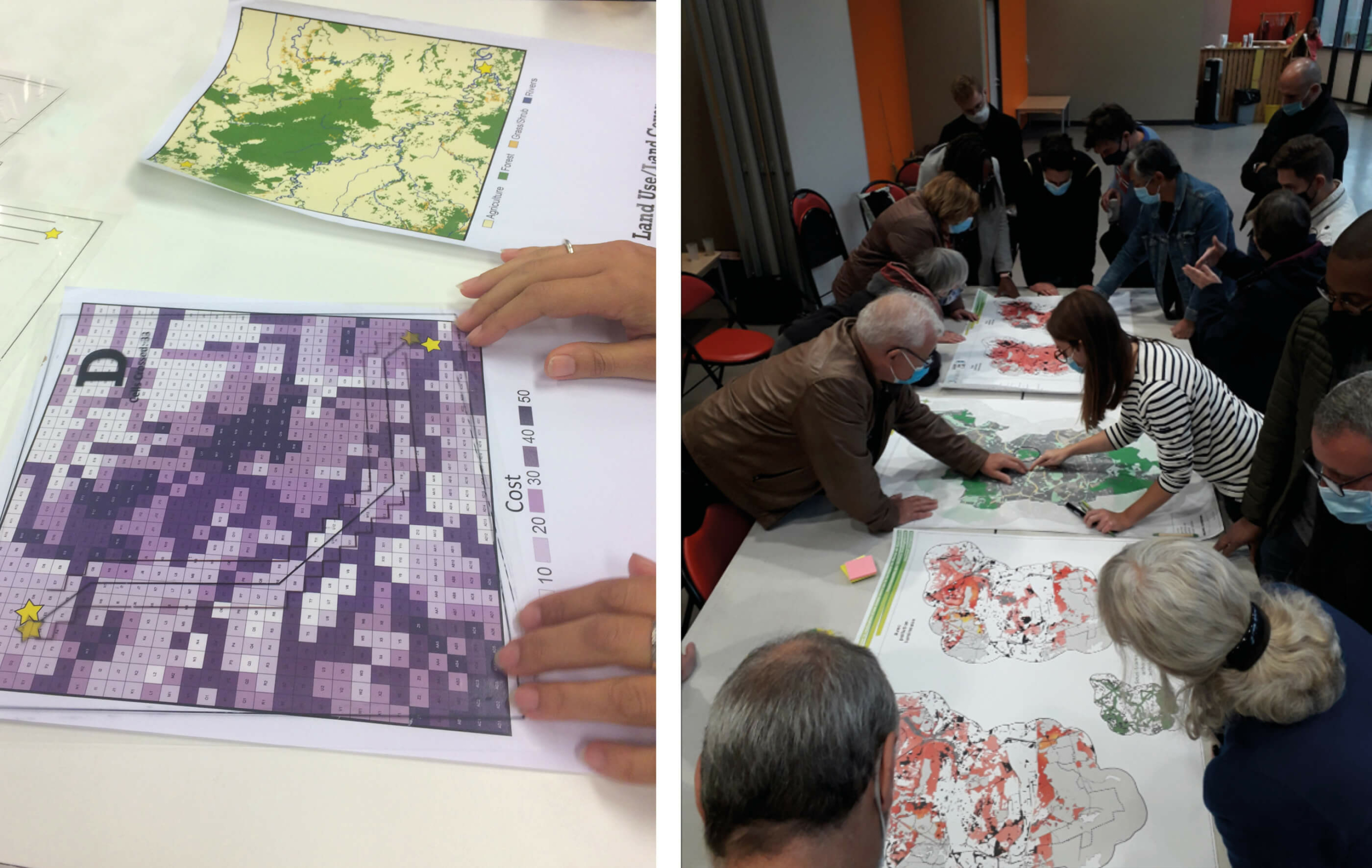
The Companion Modelling approach is designed to combine modelling methods for either human development, ecological dynamics, or both with participative processes such as workshops. Companion Modelling involves creating a continuous improvement process, that can lead to a better understanding of the different issues for all stakeholders. A strategy developed through this process takes into consideration the different points of view of stakeholders involved in the development of a territory. It can also reduce the opacity resulting from the use of modelling methods, known as ‘black box effect’ and therefore limiting the ‘expert’ effect where the knowledge of a few experts drives most of the thinking. Social sciences offer a different framework to weigh the different issues when planning infrastructure at the landscape scale. These frameworks are particularly valuable to guarantee participative approaches and take into consideration sociological drivers. Figure 4.2.3 shows examples on how this approach is used.
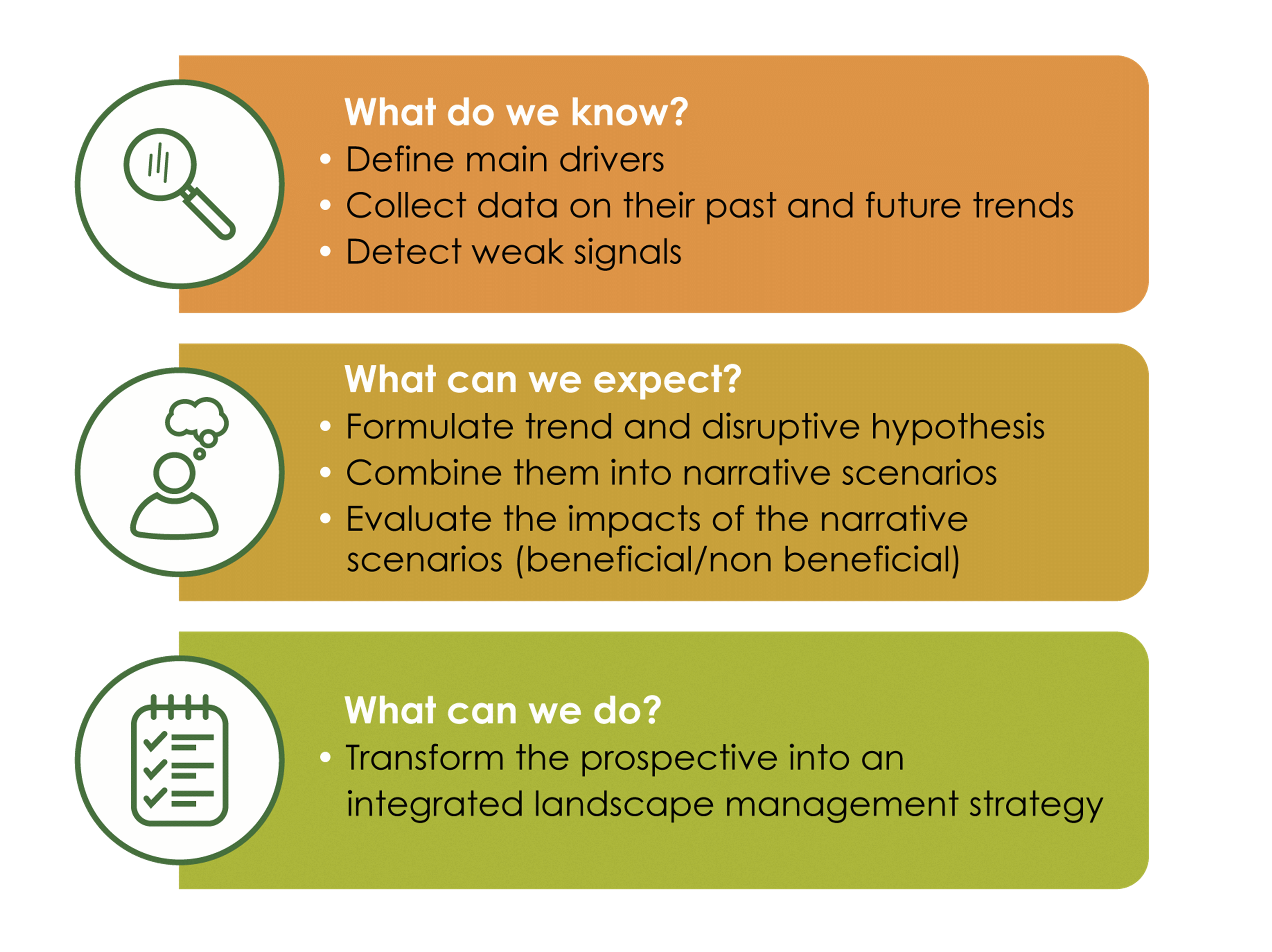
Foresight method
The Foresight method, also known as ‘Prospective method’, is a powerful methodology to address highly complex and multidisciplinary questions which can be adapted to landscape management (Figure 4.2.4). It consists of imagining the possible future of a territory based on its past and potential future trends. Then, relevant stakeholders are invited to collaboratively build scenarios for the future. In this framework, transport infrastructure can play a central role as it depends on the demographic dynamic, the local economy, and its connection to other territories.
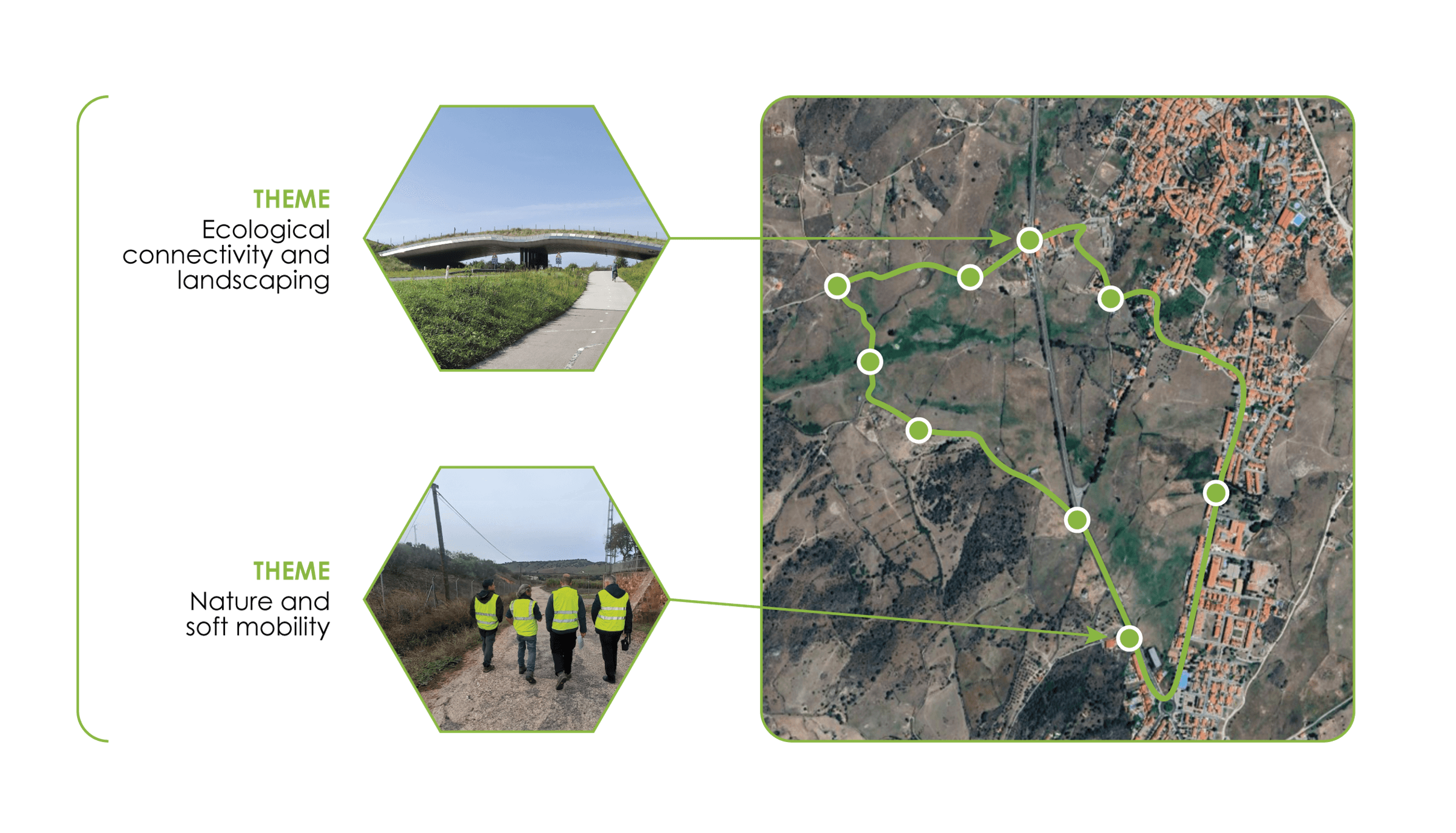
Commented Ballads
Apart from the aesthetic perspective, the subjective sensorial experience of the landscape by individuals is rarely considered in transport infrastructure design, despite being probably one the main drivers of its acceptance or otherwise. Some techniques such as Commented Balladscontribute to the expression of subjective perceptions of the infrastructure and its environment by participants and at the same time facilitate a dialog between sectors and stakeholders. Commented Ballads consists of accompanying groups of stakeholders, leading them along a planned path which passes through areas of particular interest regarding the project’s integration into the landscape (Figure 4.2.5). At each area, stakeholders can explain how they perceive the site and discuss their understanding of the project with relevant thematic experts, considering existing regulatory and technical issues. This approach is a particularly powerful way to share views about a project across different sectors such as civil engineering, biodiversity management, farming and others.