
The techniques most commonly applied to transport infrastructure projects are listed in Table 6.1 and Table 6.2. Here, we do not to present a comprehensive inventory of techniques, but only those that open up new possibilities in terms of conducting fauna or flora inventories to inform monitoring and evaluation. Given the highly technical nature of some of these techniques, it is advisable to work with professionals when applying them. As these techniques are not suitable to all situations, an informed decision must be made based on factors such as species, habitats, metrics, and sampling designs.
Techniques using cameras
Camera trap: motion/passive infrared sensors (PIR)
This equipment and its technology are evolving very rapidly and this section aims to present just the main features. The effectiveness of an inventory carried out with camera traps will depend not only on the equipment used but also to a large extent on its installation. It should consider where the animals move, the most favourable period of their biological cycle, the positioning of the detector depending on the target species (i.e., either frontally or laterally relating to how they move, and other factors). It is also important to pay attention to camouflaging the detector and equipping it with an anti-theft system.
Several parameters must be taken into consideration, depending on the objective of the camera trap like speed of triggering, image capture settings (image or video), image resolution, type of lighting, autonomy or detection zone. For successful detection and triggering, a temperature difference to the background must be present in all or part of the detection zones. Camera traps can also be combined with other non-infrared detection systems such as motion, pressure or vibration detectors, laser beams and various switches capable of sending a 6 to 9V electrical pulse to the camera trap to trigger it.
Some camera traps include remote data transmission system via GSM network. Solutions are being developed that will allow artificial intelligence to be embedded in the devices so that only the name of the identified species or only the images where a species is identifiable are transmitted via GSM.
To analyse images and identify the species detected require a high time investment and expertise. However many software, assisted by IA can help in the process applying:
- Semi-automated treatment: software can be used to detect whether an animal is present or not in a picture or appears for a time in a video, thus reducing the number of pictures and quantity of video data to process. Some examples are Megadetector®, Zilon®, AnimalFinder® or MotionMeerkat®.
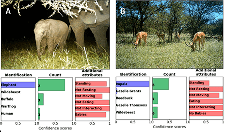
- Automated treatment: significant progress has been made in automated identification notably through the utilization of software applying artificial intelligence (AI) technology, and in particular through two kinds of algorithms: artificial neural networks (ANNs) and convolutional neural networks (CNNs). These algorithms can identify a given set of species to a confidence threshold of 95%, by firstly cropping the animal detected, then by applying the classifier model.
Some CNN-based models are even more advanced as they can identify, count and describe the behaviour of African species detected in the picture (Figure 6.3.1.). Examples of software to be applied are Agouti®, ClassifyMe®, DeepFaune®, MLWIC2® and Wildlife insights®
Advantages
- Does not disturb wildlife unless lighting is white LED.
- Inexpensive (but image analysis can be expensive).
- Easy to implement in the field.
- Potential autonomy of several weeks or months.
Drawbacks
- Realistic range limited to about 15 metres for medium-sized wildlife.
- Does not detect small fauna (except in cases of cameras with specific performance).
- Always requires a light source, daylight or infrared LED.
- The triggering mechanism may be noisy and detected by wildlife.
- Even ’no-glow’ or ’black light’ LED may sometimes be detected by animals.
- Does not detect animals in foggy weather.
Camera trap: sequential triggering techniques – time-lapse
Many camera traps can be programmed to take one or more photographs and/or videos at a given interval, ranging from a few seconds to hours. This sampling method is known as time-lapse and is similar to the stop motion filming technique. It is useful for detecting animals that have a body temperature similar to their environment and therefore not detectable using trigger passive infrared (PIR) sensors, such as amphibians, reptiles or insects.
Time-lapse produces a lot of pictures to handle, maybe even millions for long-lasting projects. Of these pictures, up to 95% of them may have no animals present, requiring the application of the automated or semi-automated systems described above for camera traps with motion/PIR sensors.
Advantages
- Inexpensive (but image analysis can be expensive).
- Easy to implement in the field.
- Suitable for ectothermic species.
- Possibility to set the time interval between each shot and the periodicity.
Drawbacks
- Less autonomy than passive infrared sensors technology, regular battery changes or solar panels supply are needed.
- Produces a great amount of data to process.
- Requires high-capacity memory cards or regular changing of low-capacity memory cards.
- Always requires a light source, daylight or infrared LED.
- Does not detect animals in foggy weather.
Thermal camera
A thermal camera records heat waves and convert these into a visible image. Heat waves are the intensity of radiation in the infrared part of the electromagnetic spectrum. A thermal camera cannot see behind an obstacle, instead, it shows the heat of a body or warm object. This device is useful for distinguishing shapes when there is a sufficiently different temperature background, meaning that a temperature difference of less than 4°C between an animal and its background will be difficult for the camera to distinguish. A temperature difference of 15 to 20°C is optimal, however high-quality thermal imaging cameras offer a very high sensitivity and are therefore better at detecting small temperature differences. Another important quality factor is image resolution of the image, which at 1024*768 pixels will provide good quality vision and better wildlife detection.
Thermal imaging is ideal for observing the movements of nocturnal mammals (Figure 6.3.2), even in the presence of light sources that will not hinder the observation. However, thermal imaging cameras are not suitable when the temperature of an animal is close to that of the environment. For example, a hibernating bat will not be visible because these species adapt their temperature to that of the cavity, thus cancelling out the temperature contrast.
Advantages:
- Operational in total darkness (unlike camera traps which always require lighting).
- It is possible to detect small animals depending on the quality of the equipment.
- Intense light sources such as car headlights do not interfere with the image.
- Can detect heat variations through fog, smoke or haze which other equipment cannot.
Drawbacks:
- Costly to achieve satisfactory quality for wildlife detection and monitoring.
- Requires training in the configuration of the device and in the analysis of the images.
- Some species, such as bats, cannot be identified by sight alone, and will require additional equipment, such as an ultra sound recorder.
Visual amplification devices
Devices used to this technique are mainly binoculars that can amplify residual light. Two types are available:
- Passive night vision binoculars, which amplify the residual light in areas immediately to hand by several thousand times with the help of a light amplifier.
- Active night vision binoculars that illuminate the scene with an infrared beam. The latter is ideal for very dark situations.
Amplifying binoculars are suitable for observing species in low light which aren’t sensitive to infrared. They can be used for example to count bats when leaving their roost. The active light amplifier combined with an infrared projector permits counting to be carried out under perfect conditions without disturbing the individuals. Where there is a source of light, such as in the vicinity of an operational road, it is not so effective due to the risk of glare from car headlights.
Advantages
- Less expensive than thermal imaging cameras.
- Light amplification permits better detailed vision than an ultra-sensitive camera.
- Suitable for all nocturnal animals and can be used on survey routes.
Drawbacks
- A minimum of ambient light is required, unlike thermal imaging cameras.
- Additional lighting, such as infrared, is required if the ambient light is insufficient.
- Any intrusive light from car headlights, street lights etc., is also amplified, which can compromise images with glare.
Ultra sensitive camera techniques
These devices use very sensitive digital sensors, which have been constantly improving over the years. Some major brands offer equipment that can capture images beyond the threshold of visibility to the human eye.
These cameras permit photography and filming in conditions where there is very little light, even a starry sky or moonlight is sufficient to capture images. The ever-improving sensitivity of these cameras offers new perspectives for quality images, if there is not total darkness.
The use of ultra-sensitive cameras has the advantage of not requiring a light source, either in the visible or near-infrared range, which could disturb wildlife. There is also the possibility of using a full range of lenses offered by the manufacturers, from wide angle to telephoto.
Advantages
- Permits photographs of wildlife in the dark.
- Can also be used to photograph the night sky, vegetation in infrared or ultraviolet.
- Permits photography or filming of scene in true colour.
- Can be combined with a wildlife detection system, active or passive infra-red, vibration detector etc.
Drawbacks
- Requires a minimum amount of light or the addition of an external light source (e.g. infrared).
Techniques using drones
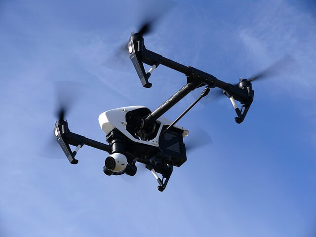
A drone or unmanned aerial vehicle (UAV) is a remotely piloted aircraft, capable of carrying devices which enable it to carry out specific tasks such as obtaining images, during the flight time.
Because the use of drones has become highly regulated and the situation is constantly evolving, relevant local authorities must be contacted for advice before purchasing or using a drone.
Over the last decade, drones have been used in a variety of ways for environmental monitoring, particularly for wildlife monitoring and inventories. They are a versatile tool that can carry image sensors using video and digital cameras, thermal cameras, ultrasound detectors and radio sensors for radio tracking among others (Figure 3.3.3).
Drones are already used for several purposes:
- Mapping of natural habitats.
- Mapping the presence of plant species that can be easily identified by aerial photography (e.g. mapping of invasive alien species).
- Detection of large bird nesting areas.
- Census or tracking of large mammals or birds (with on-board cameras or radio tracking).
The range of uses is expanding globally, and the use of drones is becoming increasingly necessary for certain purposes.
Advantages
- Drones can carry image, photo or video capture equipment as well as various sensors, which can be used for radio-tracking.
- They can be used to cover a large area quickly, to fly over inaccessible places and get an overview of a site (i.e. to count a bird colony by image analysis).
- The drone’s flight may be programmed automatically, from take-off to landing, provided necessary authorizations have been obtained.
Drawbacks
- Short autonomy limits wildlife inventory capability.
- Professional drone use may require training of pilots and authorisations may be required depending on local laws.
- Cannot be used in places with obstacles, such as in forests.
- May produce noise which disturbs wildlife sensitive to this type of sounds.
Capture-Mark- Recapture techniques
Mark and recapture is a commonly used method in ecology, primarily to estimate the size of an animal population. Animals can be marked either by fixing a physical object to an individual, a paint mark, ring, transponder, collar, etc, or by recognizing a particular natural pattern, often the animals’ coat. Reliably identifying individuals helps answer several ecological questions, including estimating the population density, studying behaviours, migratory patterns, and longevity.
Capture-Mark-Recapture
A visual, artificial mark may be put on an animal in different ways. An option are coloured marks, such as paint, felt-tip pens, markers, rings, tattoos, bee marks, and other. This technique identifies individuals or a population with identical markings on individuals of the same population, to observe the movements and behaviours of these populations. Another option applied for bird marking are numbered aluminium or stainless steel rings, which generally bear the name of the organization responsible and a code. This technique makes it possible to keep track of an animal while it is alive. To obtain movement data, it is necessary to recapture the animal, alive or dead, in order to visually read the number on the ring. Ringing is also useful in population dynamics, to obtain feedback on the survival rate.
Sight-resight
This technique is similar to capture-mark-recapture, but in this case, no marking or tagging takes place. The unique natural characteristics of some species facilitate the recognition of individuals, such as the particular pattern of an individual’s coat, spots on specific parts of the body as in the case of some amphibians or Lynx, a physical mutation like albinism, a footprint or morphometric characteristics like. This technique is usually based in images obtained by camera traps.
Genetic identification
Another method is DNA fingerprinting, which uses the nucleotide sequences of certain regions of DNA that are unique to the individual. After genetic analysis of part of an animal’s biological tissues, blood, hair, or other, it is possible to identify both the species and the individual and thus obtain information on its movements and behaviour. This is a different technique than that for environmental DNA (see Section Environmental DNA (eDNA) techniques).
Digital tracking
With this kind of monitoring technique, a transponder or similar device is placed on or in the animal. A transponder is an electronic radio frequency identification (RFID) chip that emits or receives electronic signals and can be detected by an electromagnetic field reader. There are different types varying in size, weight and autonomy, to suit different animals and applications. Passive RFID transponders are commonly called Passive Integrated Transponder (PIT) tags. The major difference between passive and active transponders is the presence of an internal power source in active ones. This battery enables the transponder to continuously transmit a signal to a RFID reader up to 150 metres away, depending on the frequency. PIT tags have a lower signal range (up to 1,5m), but they are cheaper, and have a longer life expectancy.
A similar technique is to use a GPS tag attached to the animal. Depending on the equipment the accuracy of the animal’s location varies, and the programming of locations can be adapted to the needs or biology of the species. GPS data can be retrieved by satellite, GSM, downloading at a distance of a few dozen metres), or in hand when the tag is recovered. This technique is widely used and the fitting of a GPS collar makes it possible to combine the tag with other activity sensors such as an accelerometer, heart rate and temperature monitor, a camera, proximity sensors, etc.
Advantages
- Suitable for the identification of a particular individual.
- Relatively inexpensive for many species (depending on the method)
- It is a preferred tool for learning about the movements of animals.
- Can also provide valuable information on ecology of a species, such as habitat use or demographic data (e.g. longevity) or ethology, like behaviour when faced with a reduction in its habitat or changes in light, temperature and other
Drawbacks
- Marking animals almost always requires the individual to be captured, which makes it. necessary to consider animal welfare and obtain administrative authorizations.
- Threatened species sensitive to disturbance are not suitable for this type of monitoring.
- Techniques requiring the capture of fast-moving and shy animals such as wolves are more expensive to set up.
Acoustic techniques
Techniques based on registration of sounds are regularly used to undertake ornithological inventories and to detect mammals whose sound emissions are clearly characteristic of the species, such as the barking of the roe deer, howl of wolf, croak of frog or whistling of marmot. It is also often used for amphibians and certain insects such as orthopterans or cicadas.
Bioacoustics and ecoacoustics can be distinguished. Bioacoustics is a cross-disciplinary science that combines biology and acoustics, which normally refers to the investigation of sound production, dispersion, and reception in animals. It examines the behaviour of animals through their vocal communication, changes in evolution through the similarity or dissimilarity of the voices of related species, the long-term and short-term species composition of animals inhabiting different habitats and their changes perceived through vocal manifestations. Bioacoustics application in transport infrastructure projects is mainly for undertaking inventories of species such as amphibian, bird and bat.
Ecoacoustics use sound as source material from which to infer ecological information such as the ecology of populations, communities, and landscapes. It can provide information to a transport infrastructure project regarding the evolution of biodiversity over time as a function of climate change and monitor the effectiveness over time of environmental restoration or compensatory measures using acoustic indices.
Acoustic techniques applied to transport infrastructure monitoring
New technologies that can be used to improve the monitoring of transport infrastructure projects combine equipment to record animal sounds with AI-based applications to automatically identify species, using a recorder with a sufficient autonomy – normally several days – which can register sound in a frequency range adapted to the species being inventoried.
Once the recordings have been made, it is possible to upload the files to servers which carry out automatic identification. Although some specific applications exist for both bats and birds there is no such readily available solutions for automatic recognition of other animals such as insects or amphibians. Using automatic or ‘AI’ solutions does not always produce infallible results, so verification of results by experts is recommended.
Acoustic techniques applied to analyse animal movements
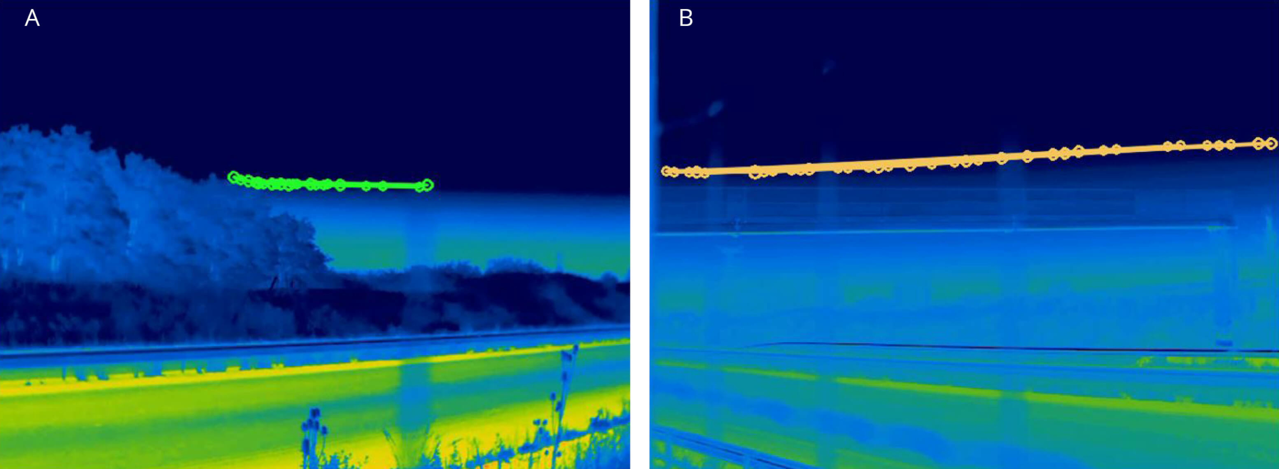
For animals that make sounds as they move, such as bats, it is possible to analyse movements by trajectography, capturing the sounds they produce with microphones triangulated or in a tetrahedron format to provide better accuracy in a three-dimensional space (Figure 6.3.4.). The time differences between sounds recorded by each microphone are measured to determine the position of the animal in space using a software algorithm, making it possible to determine the height, direction and speed of flight. For bats, it may even be possible to determine hunting, transit, avoidance of a vehicle or other type of behaviour.
This technique may be useful in the context of transport infrastructure projects in the analyse of sensitive species – particularly bats – behaviour related to e.g. traffic, fencing or crossing structures.
Advantages
- Acoustic techniques do not disturb the animal, operating without human presence or emitting any sound.
- Inexpensive
- Long battery life of up to several weeks.
Drawbacks
- Suitable only for animals that produce sounds – such as bats, which produce sounds during their entire movement.
- Can only operate during the vocal period when animals such as birds, amphibians and insects make their sounds.
- Less suitable for mammals, for which much better results are achieved with camera traps.
- Large recording storage capacity is required for recorders that operate continuously.
- Auditory analysis can be tedious but may be supported using increasingly capable artificial intelligence software.
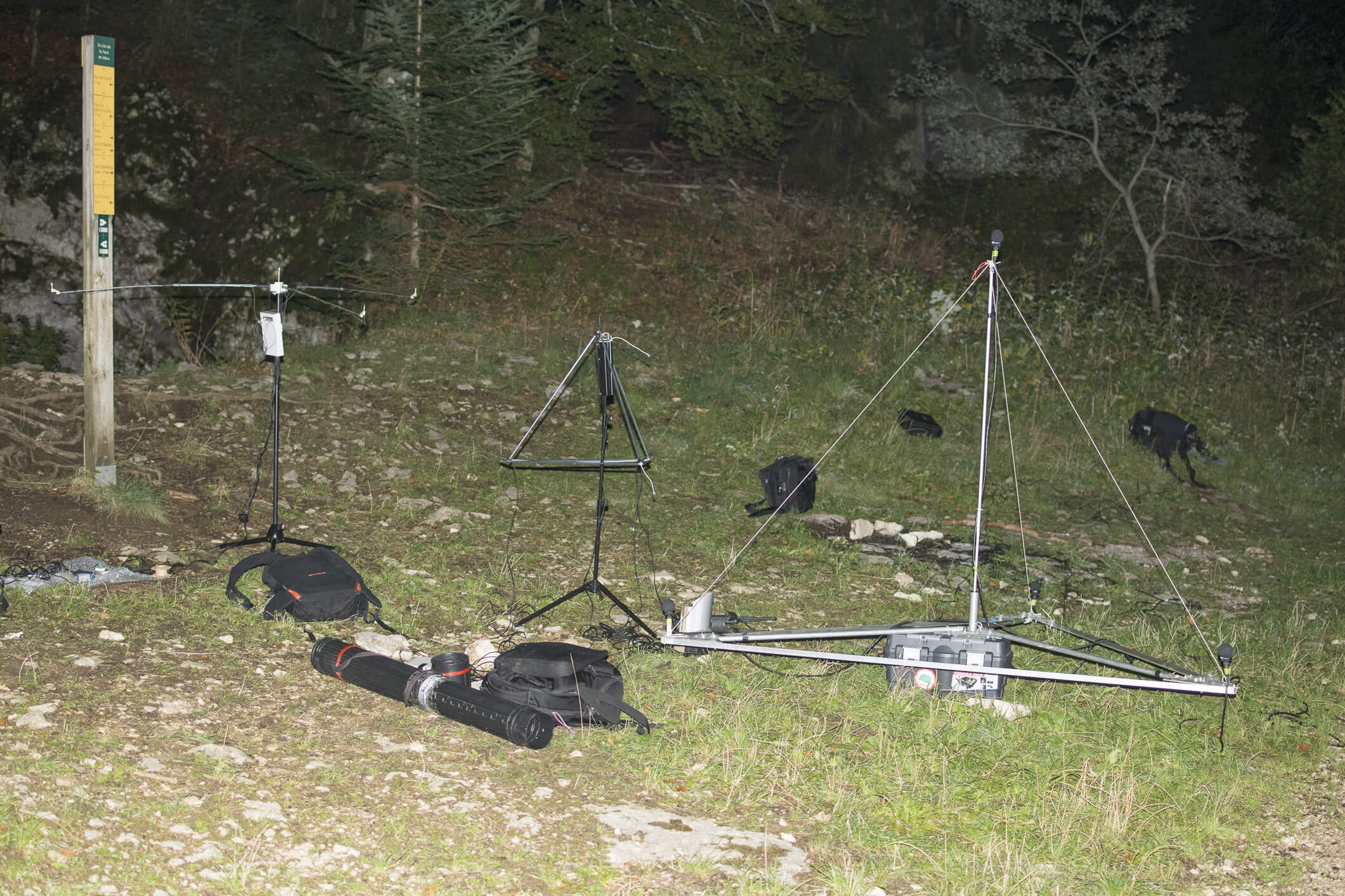
Radar detection devices
Similar to sound wave reflection, radar uses pulses of electromagnetic energy in the form of microwave signals emitted in the direction of a target. A small part of the transmitted energy, known as an echo, is reflected by the target in the direction of the radar, which is used to determine the direction and distance of the object that has reflected the radar signal.
There are several types of mobile units that can be are mounted on a trailer, that can be attached to the vehicle permanently (Figure 6.3.5A) or left on site for several months (Figure 6.3.5B) to carry out continuous data acquisition.
Radar technologies can be applied to monitor bird movements and they have specific applications in airports to analyse birdstrike risk, and powerlines to analyse collision risk.
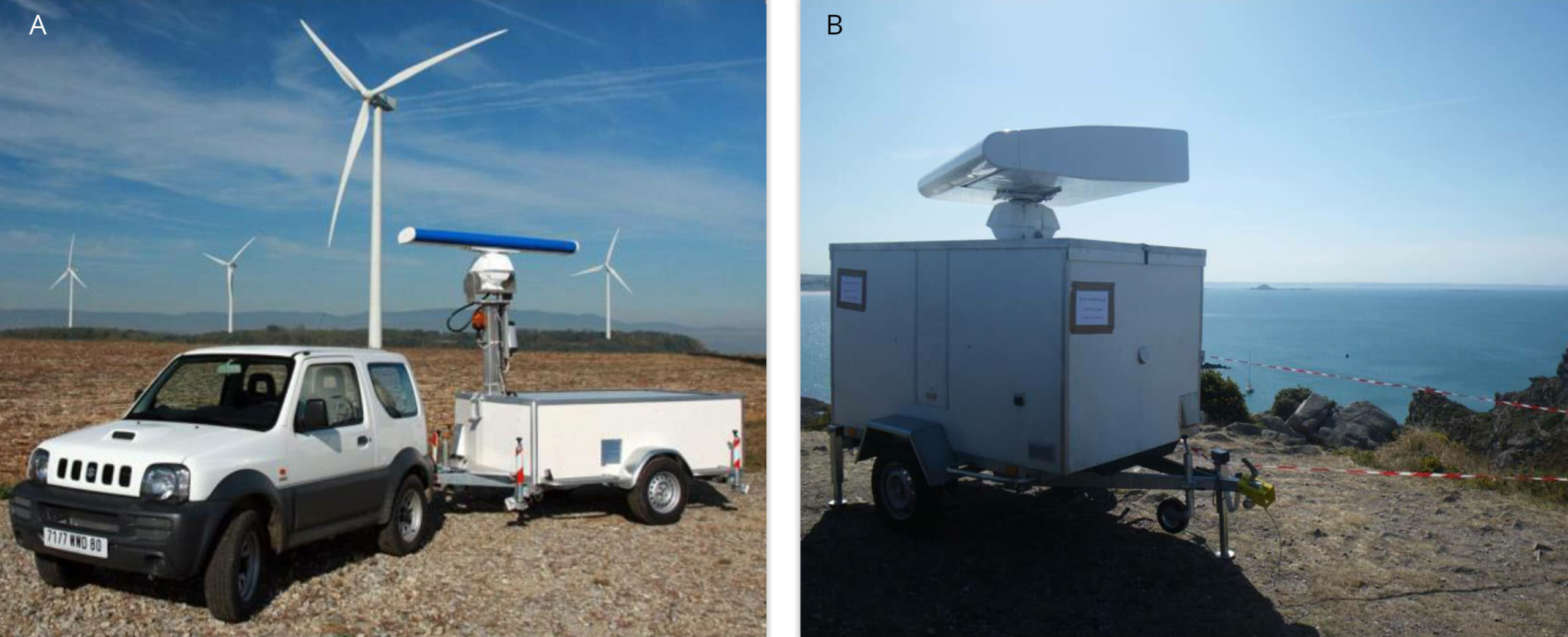
Advantages
- Enables the detection of large birds or large formations of birds of all sizes over a very large distances.
- Provides data which facilitates better understanding of the movement of birds, especially during migration.
Drawbacks
- Does not normally enable particular species to be identified, except in the case of characteristic flight formations and wingspans (e.g., cranes or geese in their V-shaped flight arrangement).
- Requires a synchronous identification of species using an experienced ornithologist.
Satellite-based techniques
Satellite techniques are generally used in two different monitoring applications related to transport ecology: mapping natural habitat and elements that fragment ecological continuity (physical barriers such as roads or sensory such as traffic noise barriers), and mapping animal migration.
Mapping natural habitats and fragmentation
Aerial and satellite devices can be used to monitor aspects of an ecosystem that are observable from above, not located underground or below a tree canopy. For almost 50 years, satellite data and images have contributed to a considerable leap forward in our knowledge of the planet and are now widely used for a variety of applications. The short time between visits of a passing satellite and the revisiting time, enables very frequent updating of land use maps. Satellite or aerial images can be of different resolutions depending on the device capturing these. Sentinel 2 satellites have a ground resolution of 10 m while newer satellites, such as Pleiades, offer up to 30 cm. Ariel satellites can provide resolution of 10 cm or higher resolution. However, the interpretation and attribution of certain land uses such as wetlands, some types of grasslands, scrublands and bare soil is limited.
While satellite images are well suited for landscape study, most images are at a resolution that does not yet enable the identification of animal species, smaller vegetation or finely detailed monitoring of an area.
Advantages
- Satellite images can provide frequent data to observe changes over time.
- Aerial image analysis is well suited for frequent large-scale monitoring at the landscape or ecosystem level.
Drawbacks
- Satellites produce large datasets requiring long time to analyse even if IA based software reduce it.
- Satellite images techniques cannot provide all information required for interpretation and require complementary techniques to be applied.
Animal movements and migrations studied with satellite tracking systems
Migration studies can be facilitated using telemetry via satellites which allow to register and analyse wide range movement patterns on a global scale.
GPS technology and transmitter size reduction enables the observation of relatively fine-scale movement or migratory patterns across far larger areas than radio-tracking a free-ranging wild animal could achieve. The position data (X, Y and Z-altitude-) transmission often use Argos system.
Nanotechnology has extended the variety of animals which can be monitored, with GPS PTTs available to conduct surveys for even passerine sized animals. However, battery miniaturisation has not advanced at the same pace, resulting in limitations on the duration and in the precision of monitoring the smallest PTTs. Coupling this technique with other devices and sensors does permit research in a variety of different study topics.
Advantages
- No limit in study area and scale, from local to worldwide.
- Potentially enables the monitoring of a large number of individuals on the same survey, proportional to the available budget.
Drawbacks
- More expensive than radio-tracking.
- A compromise is required between the frequency of position recording and the subsequent drain on the lower-capacity batteries when using the smallest transmitters.
Environmental DNA (eDNA) techniques
Environmental DNA is released by an organism into the natural environment through e.g. urine, droppings, hair or moults and is a complex mixture of nuclear and mitochondrial DNA from different organisms. It is composed of intracellular DNA from living cells and extracellular DNA from dead cells. Detection of DNA from a species is possible at any stage of its life cycle.
The conservation time of DNA in the aquatic environment varies according to physio-chemical parameters like temperature, pH, exposure to UV rays. The persistence of DNA varies from a few hours to about 1 month, but in running water, persistence is only about one hour). In terrestrial soils and sediments, the persistence of environmental DNA is much higher than in aquatic environments, reaching hundreds or even thousands of years. These conservation periods are important to consider because the shorter they are, the stronger the evidence will be for the recent presence of a species, but there will be no information about its past presence. Conversely a long conservation period will demonstrate that a species has been present in the past but without information on whether the species was recently present.
DNA samples fare better in small areas of aquatic environments, especially stagnant water, than in large areas, and especially in running water. Good results are also obtained from identification species droppings. Similarly, it is easier to detect DNA from animals that release more of it, such as amphibians and fish which have thin and fragile skin, in contrast to arthropods, which have a tough exoskeleton and release less DNA. The higher the population density of a species, the better the chances of detecting the DNA of that species.
Advantages
- Enables the detection of species that are difficult to observe using more conventional methods.
- Species can be identified without any disturbance.
- Possible to identify ~90% of species for certain groups, particularly amphibians.
- For aquatic environments, knowing that the DNA is no longer detectable after one month makes it possible to be sure that the species were recently present.
Drawbacks
- The eDNA technique indicates only a presence or absence of a species and does not provide information on the size of a population.
- Does not provide information on the age of individuals, whether they are breeding or not, their state of health or other factors.
- The exact location of the species cannot be determined with this technique.